The AT running through several National Parks, as well as being part of the National Park system, it is of interest that the Department of the Interior has changed the regulations regarding the possession of concealed firearms in national park areas and national wildlife refuges.
Prior to the rule change, firearms were not permitted in national parks unless they were unloaded and locked in a trunk. This was inconsistent with regulations with respect to lands under the control of the U.S. Forest Service or the Bureau of Land Management, which, generally speaking, apply the respective law of the state in which the land lies. As of January 9, 2009, if you possess a valid concealed carry permit in Virginia, you will be able to legally carry a concealed firearm in National Parks in Virginia.
This change in NPS regulations was requested by 51 U.S. Senators from both parties. The Federal Register notice indicates that the Department of Interior received approximately 125,000 comments to the original proposed rule, much more than most notices of proposed rulemaking receive.
Although there are arguments against the change, many of them fail to reflect reality (e.g., federal law enforcement can provide adequate protection in the many square miles that people cover in the National Parks, or there will be an increase of criminal activity). The new rule provides a consistency within the individual states that allows those legally carrying a weapon for self defense to do so with some confidence.
Thursday, December 11, 2008
Sunday, August 17, 2008
Bullfrog: Second Leg in Central Virginia
On August 9-10, 2008 Rhino and I headed back to the Trail after what felt like an extremely long two and a half months. Joining us were guest hikers Robert (from two previous hikes) and Jen.
We started at the Tye River and hiked south 19.5 miles. It was a long hike up "The Priest" from the River (about 3,000 ft. up over about 4 miles). On the way up we encounted an angry swarm of bees which managed to hit me once, and Rob and Jen a couple of times each. Rhino avoided having his tough hide breached by the stingers.
We ended at Hog Camp Gap where there was a nice meadow right before the Forest Service road where we parked.
Tuesday, June 17, 2008
Rhino: Hiking News
1. First the Oh Crap! News. They extended the Appalachian Trail all the way to Alabama connecting it with the famous Pinhoti National Recreation Trail.
Now we have to go to Alabama too.
2. Now the OMG News. UltraRunner Karl "Speedgoat" Meltzer is going to try and break the Speed record for the AT. His Goal 47 days 13 hours and 31 minutes. He will be traveling light with a support crew and sleeping in a bed every night...but I got to tip my hat. Thats gonna be rough. The cool thing is he will be wearing a GPS so we can track his progress on his web site.
karlmeltzer.com
3. Finally what will we do when we complete the Appalachian Trail, Pacific Crest Trail and the Continental Divide. Why the next big fad will be the North Country National Scenic Trail (NCT) This behemoth of a cross country trail will stretch all the way from New York to North Dakota...
Check it out here.
http://www.northcountrytrail.org/
Jeff "Rhino" Morgan
Friday, June 13, 2008
Good quote
Too often I would hear men boast of the miles covered that day, rarely of what they had seen. -Louis L'Amour, novelist (1908-1988)
Saturday, May 31, 2008
First Leg South of the Shenandoah National Park
Last weekend -- Memorial Day weekend -- Rhino and I continued our Southward journey on the AT. We picked up where we left off last September at Rockfish Gap, at the bottom of the Shenandoah National Park.
Our initial plan was to start Friday and finish sometime Monday. I took Friday off, but Rhino had an important meeting at his work that was specifically about Rhino ... so he had to be there. But he was able to take off early, and was on the road, heading West, by 1 pm.
Day 1
We met at Gander Mountain, on the South side of Winchester, and picked up a two-man tent, a nice, light Kelty that would be lighter than our individual tents. We then headed South to drop off one of the cars. After a slight detour (i.e., Bullfrog's failure to exit I-81 at the right place), with excellent input from Bullfrog's wife, we meandered down Route 56 until we got to Fish Hatchery Rd., just past Montebello, VA.
At that point, we stopped and I explained that if we went up Fish Hatchery Rd., we would have to hike about 38 miles, but if we continued down 56, we would have to hike "only" 30 miles. After a brief consultation, we decided to do the 30, and parked on 56, just across the road from Tye River.
We dropped off my car (shall I call it the Gray Goblin?), and I piled into the Gray Ghost. Looking at my trusty map, I directed Rhino to a shortcut (like 10 miles shorter) which took us on a gravel road up several switchbacks up a mountain. We finally made it to Rockfish Gap, where we unpacked the new Kelty tent, and repacked our packs with just the supplies we would need.
We hit the trail around 5 pm, hoping to get five miles to the base of Humpback Mountain before nightfall. We approached the Paul C. Wolfe shelter right around 8:30, found that it was full (not that we were disappointed, since we weren't planning on staying in it) and proceeded to find a site and set up our tent. After a Mountain House meal of beef stroganoff and a brief chat with a through-hiker camping near us, we settled down to a nice night. The ambient sound of the cascading stream near us made it difficult to hear random sounds of the night that make it difficult to focus on sleep.
Day 2
In the morning, we split a Mountain House granola and blueberries as we broke camp. We were on the trail around 8 am, and began to ascend the Humpback. We saw quite a few through-hikers heading North, sometimes stopping a few seconds to chat and sometimes just passing quickly. They started in Georgia in March, and while not all of them are going to make it to the end, they were all trail-experienced by this point.
We got to the top of Humpback and had a lunch of tuna and some trail mix and jerky. We continued and ended up stopping around 6 pm for the night atop a cliff (Ceder Cliff?) overlooking the Shenandoah Valley a couple thousand feet below us. We ate an old Mountain House beef stew. I watched over the last couple of hours of evening as a farmer below was round-baling a hay field. It was beautiful watching the sun set over the mountains to the West as the valley faded into dark and the various lights began to twinkle and take effect. Several bonfires were light around the valley just as it got dark. We didn't use our new tent, instead sleeping about 20 feet back from the cliff, with the AT between us and the edge.
We got 10 miles in that day, and although we had two days available ahead of us, were beginning to think about finishing the final 15 miles the next day.
Day 3
Sunday began for me as the eastern horizon began to show a bit of light (I could see Northeast, up the Valley). I didn't sleep again, and watched as the horizon brightened, the Valley began to awaken, and finally the sun peeked over the hills. I made some Mountain House eggs, into which I put some BBQ pork jerky for flavor/variety. We had Three Ridges to look forward to, only about a 1,500 climb (but over several miles). However, we still weren't sure how far we were going to go that day.
After crossing Bee Mountain, we began the ascent of Three Ridges, sometimes quite steep, some of the steepest climbs we've had the whole time. The actual peak had no views as it was covered with mature trees. Rhino took a quick nap at the top, and I wandered around and did find a rock with some ok views of the valley to the east.
The descent from Three Ridges down to Tye River was 3,000 feet over about 6 miles. As we descended, we were running out of water, and made refilling our main objective. Some of that descent was very steep, with lots of switchbacks. A through-hiker ascending Northward convinced us to go ahead and finish that day. It looked like we were going to have plenty of time, but would make the final decision once we got to Harper's Creek, where we would refill and have a place to camp if we wanted to. However, after refilling at the cold waters of Harpers Creek, we decided to sally forth and finish, pick up the Gray Ghost and head into Waynesboro to the A&W for some burgers.
We did finish and even made it to the Gray Ghost just as it was getting dark. Rhino wanted to get a room at a motel. We drove down into Waynesboro, but when we got to A&W, we found that their root beer tap was out of order ... and they didn't have any hamburger meat! So we ducked out of there, ate across the street, fueled up, and found that the motel was full (probably with through-hikers). We decided to head to our respective homes, and completed the weekend.
And yes, Rhino got poison ivy.
Friday, January 25, 2008
I've got a serious hankerin'

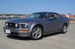
Bullfrog: I can't quite explain to you all of the feelings I've got seeing this picture right now ... other than I've got to hit the trail!!!!
 Rhino: we did hit the trail in January but instead of traveling south we decided to do a day hike in Maryland. We started at Gathland State Park which was once the mountain home of George Alfred Townsend, a Civil War journalist. It is the site of a unique collection of buildings and structures that he designed and constructed, some of which have been restored. A large, stone monument dedicated to war correspondents is an outstanding attraction at this day use park. The park includes all of Crampton's Gap, which was the southern most gap fought over during the battle of South Mountain. Fought September 14, 1862, it was the first major battle of the Civil War fought in Maryland.
The picture is from the web. When we arrived early that morning, the weather was cold and there was thin layer of crunchy snow on top of the mountain. Jeremiah and I had packed light
 since we wouldn't be staying overnight. We made some serious good mileage that morning as we hike the crest of the mountain. Eventually we arrived at the famous Weverton Cliffs. We both ate a power bar and rested on top of the cliffs. When we descended we joined the C&O Canal bicycling path for three miles of easy walking...but we were getting tired. Walking next to the Potomac we approached the Bridge into Harpers Ferry, where we stopped for an expensive burger and fries. Harpers Ferry was very nice and I would like to go back to visit someday. We stumbled to our cars finishing a blistering 15 miles in one day. Granted it was easy terrain with little mountain climbing but it was a very satisfying hike.
Subscribe to:
Posts (Atom)